From exploration to production — unify geophysics, geochemistry, drill, and remote-sensing data into analysis-ready stacks, prospectivity models, and explainable dashboards your geologists can defend.
Part of our broader AI practice — see how we ship AI to production and the full AI & ML solutions catalogue.
Mining and geology now depend on the intelligent use of multi-modal data: geophysical surveys, geochemical assays, hyperspectral imagery, structural mapping, satellite data, and decades of historical exploration archives.
PositionMySite helps exploration and mining teams integrate, analyze, and model these layers into ranked targets, uncertainty-aware maps, and QA/QC’d pipelines — with geologists in the loop. Outcomes depend on deposit type, data density, and program design; we scope realistic milestones after a data audit, not headline promises.
We help exploration and mining organizations turn geological data into a governed, predictive asset — not a black box.
We integrate decades of exploration data and build AI models that identify high-probability drill targets — transparently and securely
We consolidate decades of fragmented exploration data into unified, analysis-ready pipelines. Multi-format ingestion (shapefiles, LAS, GOCAD, GeoTIFF, CSV), spatial harmonization, legacy data digitization, and comprehensive QA/QC workflows.
Custom machine learning models that identify mineralization patterns and optimize drill planning. Ensemble learning (GBDT, CNNs, GNNs), spatial cross-validation, active learning loops, and uncertainty quantification for confident predictions.
Spatial AI to prioritize high-probability zones and reduce wasted drilling. Prospectivity mapping, anomaly detection, multi-criteria ranking, and risk-adjusted target selection to maximize exploration ROI.
Transparent, interpretable results geologists can trust. SHAP attribution maps, feature importance overlays, "what-if" scenario modeling, and GIS-ready exports that show exactly why the AI made each recommendation.
GPU-accelerated pipelines, private cloud options, and Canadian data residency. Kubernetes deployment, on-prem or cloud (AWS Canada, Azure Canada), customer-managed encryption keys — availability targets are defined in your statement of work.
Your data remains your proprietary asset—always. Isolated environments, customer-managed keys, SOC 2/ISO 27001 compliance, and contractual guarantees that we never commingle or reuse client data.
A proven 8-stage process to transform your geological data into decision-grade intelligence
We sign mutual NDAs and conduct a comprehensive audit of your existing datasets, formats, and data quality. Identify gaps, assess completeness, and establish data governance protocols.
Define project scope, success metrics, and deliverables. Identify AI opportunities specific to your exploration program and establish baseline performance for comparison.
Consolidate multi-format geological data (shapefiles, LAS, GeoTIFF, CSV, legacy archives) into unified, analysis-ready pipelines. QA/QC workflows ensure data integrity.
Build predictive models using ensemble learning (GBDT, CNNs, GNNs) and spatial cross-validation. Develop explainable AI features that geologists can interpret and trust.
Validate models against historical drill results to establish baseline accuracy. Iterate based on geological input and refine targeting algorithms for your specific geology.
Deploy interactive dashboards with GIS integration (ArcGIS, QGIS). Train your exploration team on the system, including how to interpret AI outputs and export results.
As new drill data arrives, models continuously learn and improve. Active learning loops ensure predictions get more accurate with each drill program.
Performance monitoring, model retraining, and infrastructure optimization. Regular check-ins to ensure the system evolves with your exploration strategy.
All models and datasets remain your proprietary assets — we never commingle or reuse client data.
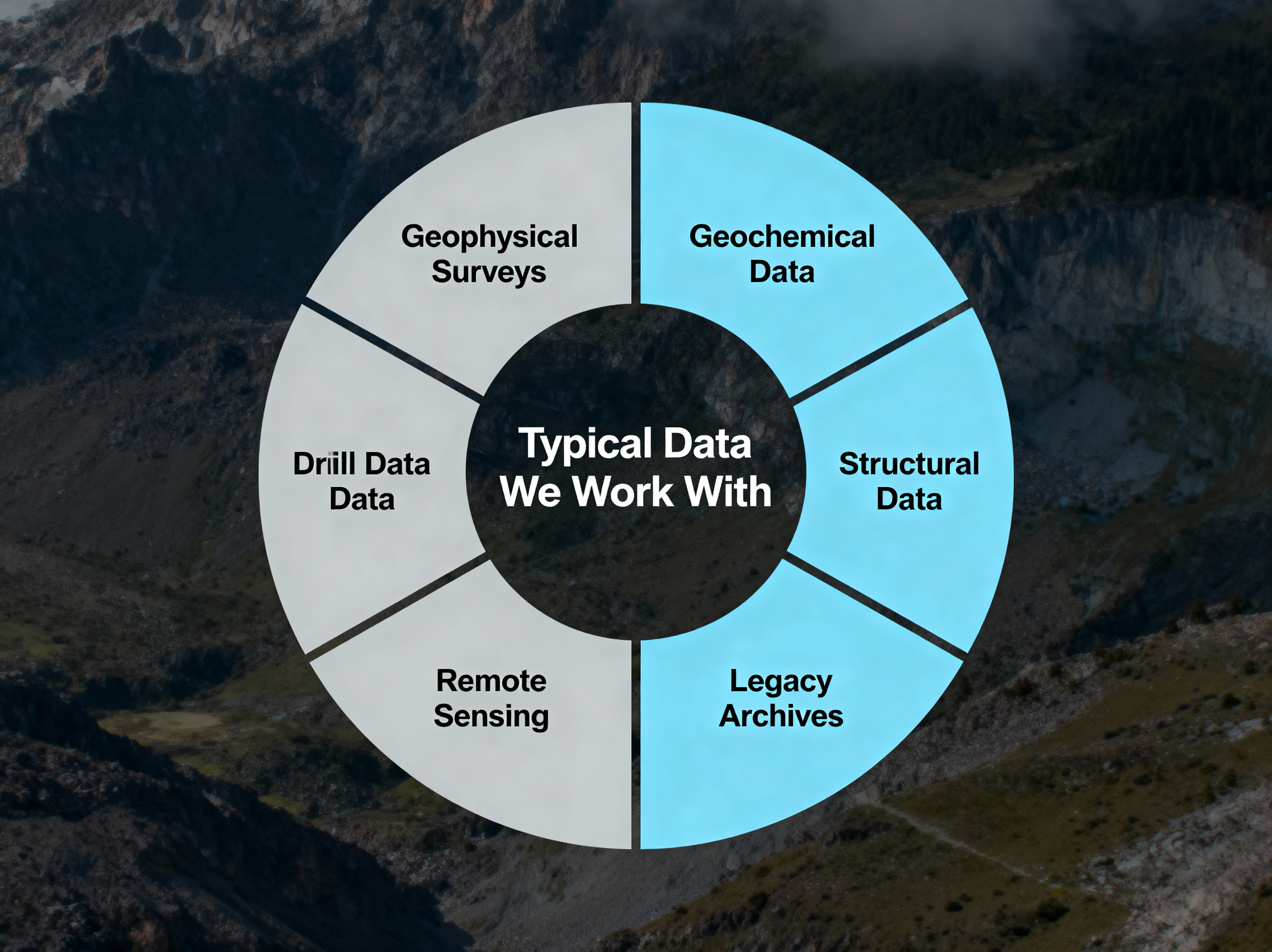
We process and integrate multi-modal geological datasets from multiple sources
Magnetic, gravity, electromagnetic (EM), and radiometric surveys that reveal subsurface structures and anomalies critical for exploration targeting.
Soil, rock, and stream samples; assay results; pathfinder elements and geochemical signatures that indicate mineralization potential.
Fault networks, lineaments, contact zones, and structural interpretations that control mineral deposit formation and location.
Core logs, downhole geophysics, historical assays, and drilling records that provide ground-truth validation for models.
Hyperspectral imagery, satellite data (Sentinel-2, Landsat), alteration mapping, and multi-spectral analysis for regional exploration.
Historical reports, paper maps, scanned data, and decades-old exploration archives that contain hidden value when digitized and integrated.
Literature and field programs report strong results when ML is paired with rigorous geology — your mileage depends on terrain, commodity, and data history. The grid below illustrates directional themes we design toward, not guarantees.
Directional theme: fewer wasted meters when targeting is ranked and uncertainty is explicit.
Models prioritize ground to test first — validated against history and geology, not hype.
When data is harmonized early, cycles from audit to ranked targets compress.
Digitized + georeferenced history often surfaces anomalies invisible to legacy tooling.
Illustrative themes from industry literature and analogous programs — not a promise of results for your property. Every engagement starts with an NDA and data audit.
The scenarios below are illustrative — shaped like programs we run, not a guarantee for your ground. Outcomes depend on geology, data density, and how models are validated.
Old geophysics and assays can surface anomalies that are easy to miss when layers stay siloed. In programs like this, teams often integrate decades of magnetic/gravity and geochemistry, then use ML-assisted detection and ranking so geologists can focus meters on the most coherent signals — with backtests and walk-forward validation before drills move.
Predictive models rank exploration blocks so budgets hit the highest-information drill sites first. On large land packages, we often rank dozens of candidates using geophysics, geochemistry, and structure — then stress-test rankings with spatial CV and geologist review so “top decile” targets are defensible, not black-box picks.
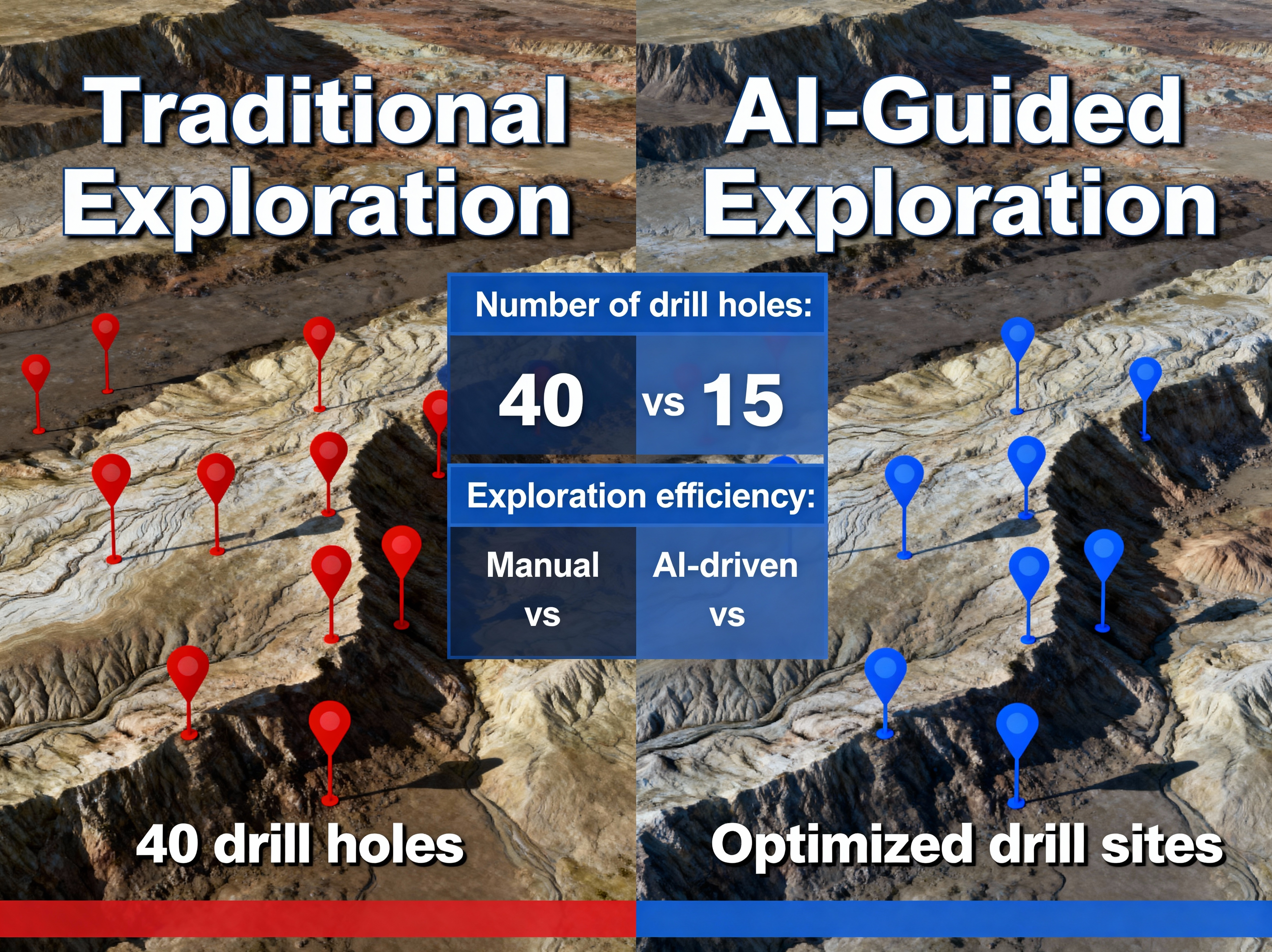
Tighter targeting can mean fewer holes for the same information — when uncertainty is explicit and the program is designed with geologists. In comparable studies and pilots, teams model reductions in meters drilled, footprint, and calendar time; your geology and permitting path still set the floor and ceiling.
Example outcome cards are for discussion only — not forecasts for your property or jurisdiction.
Built on Kubernetes, PyTorch, TensorFlow, and LightGBM — deployable in AWS Canada or private on-prem clusters
All models are built with reproducible workflows, tracked with MLflow/DVC, and deployed via CI/CD pipelines. Every prediction can be traced back to its data sources and model version.
We combine deep AI/ML expertise with understanding of geological workflows to deliver systems geologists can trust
Every AI recommendation includes SHAP attribution maps, feature importance overlays, and "what-if" scenario modeling. Geologists see exactly why the model made each prediction, building trust and enabling informed decisions.
Your geological data remains 100% yours. Isolated environments, customer-managed encryption keys, SOC 2/ISO 27001 compliance, and contractual guarantees that we never commingle or reuse client data. Your discoveries stay your discoveries.
Deploy in AWS Canada (Montréal/Toronto) or Azure Canada regions for full Canadian data residency. Alternatively, deploy on-prem in your own infrastructure with full control over data location and access.
We handle all data types—geophysics (MAG, GRAV, EM), geochemistry, drill logs, hyperspectral imagery, satellite data, and legacy archives. Seamless integration across shapefiles, LAS, GeoTIFF, CSV, and proprietary formats.
From data audit to pilot model deployment in 30-45 days. We don't need 12 months to prove value—our pilot programs deliver actionable insights quickly, allowing you to validate the approach before scaling.
All AI outputs integrate seamlessly with ArcGIS, QGIS, or custom web dashboards. Export probability maps, target rankings, and model predictions as GIS layers for immediate use in your exploration workflows.
Get answers to common questions about AI for geological exploration and mining
At minimum, we need 3-5 years of geophysical surveys (MAG, GRAV, EM), geochemical data (soil, rock, assay results), and any historical drill data. The more data you have, the better—legacy archives, satellite imagery, structural mapping, and historical reports all add value. We can work with fragmented or incomplete datasets; data cleaning and integration are part of our process.
In many published studies and field programs, ML-guided workflows have improved hit rates or reduced meters drilled versus baseline workflows — but geology, commodity, and data density dominate outcomes. We use spatial validation, uncertainty, and SHAP-style explanations so geologists stay in control of drill decisions.
Absolutely not. Your geological data remains 100% proprietary to you. We deploy in isolated environments with customer-managed encryption keys. Our contracts explicitly prohibit data sharing, reuse, or commingling. Every project is completely isolated—your discoveries, datasets, and models never leave your control. We can also sign NDAs and deploy in your own infrastructure if preferred.
A typical pilot takes 30-45 days from data audit to initial model deployment. Week 1-2: Data assessment, cleaning, and integration. Week 3-4: Model development and validation. Week 5-6: Dashboard deployment and training. Most clients see actionable insights within the first month, allowing you to validate the approach before committing to a full-scale deployment.
Yes! We specialize in digitizing and integrating legacy exploration data. Paper maps, scanned reports, historical assay records, and decades-old surveys can all be converted into analysis-ready digital formats. In many cases, these legacy datasets contain hidden value—old geophysics reprocessed with modern AI techniques often reveals anomalies that were invisible with 1980s-era analysis methods.
Tell us about your geological data and exploration goals. Whether you're optimizing exploration or digitizing decades of legacy data, we can help you build AI systems tailored to your geology, your datasets, and your infrastructure.